Tower of the Twelve | Vipiteno

How to reach the Zwölferturm

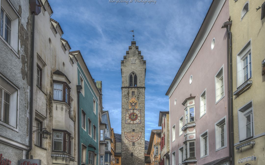
The Tower of the Twelve in Vipiteno, the landmark of the Fugger town, is located at the end of the medieval old town.
One of the sights of Vipiteno (Sterzing) – besides the churches, museums and the Vipiteno City Hall with the Stone of Mithras – is the Tower of the Twelve, which separates the old town from the new town. It is called “Zwölferturm” in Geman and “Torre delle Dodici” in Italian. The tower is not only the landmark of Vipiteno, but with its 46 metres also its highest building.

Its name probably derives from the fact that its bell rings at noon and has always called the citizens to lunch. The Tower of the Twelve was built between 1468 and 1472 above the town passage and was thus used a the upper town gate. This was at a time when the nearby silver mine in the Val Ridanna valley led the region to prosperity and Vipiteno experienced its boom as a Fugger town. Two marble slabs above the archway still remind of the laying of the foundation stone by Sigismund, Archduke of Austria, in 1469.

In 1867, the Gothic pointed roof burned down and was replaced by a stepped gable. Temporarily, the tower served as the seat of the fire brigade, who had a good view on the entire town from there. Today the Tower of the Twelve can be visited on some special dates. During the Advent and Christmas season, the small wooden huts of the Vipiteno Christmas Market are placed around it. And how to reach the tower? It is located between the old town and the new town of Vipiteno, various parking facilities are nearby, e.g. the Centrum or the Piazza Europa car parks.

Opening hours: from the end of November 2019 to the beginning of January 2020
visits are possible during the Vipiteno Christmas MarketKontakt:
Zwölferturm

Neustadt 1
39049 Sterzing
+39 0472-765325

Passo Gardena | Gardena

How to reach the Passo Gardena

The Passo Gardena (Jëuf de Frea in Ladin) proceeds from Selva di Val Gardena to Colfosco, which is part of the municipality of Corvara and with 1,645 m asl. the highest located holiday resort of Alta Badia. A little below the Passo Gardena, findings from the Stone Age were made, a driveway up to the mountain pass was built in 1915, during World War I.

The alpine world on the Passo Gardena is awesome: to the south the massy Sella Group, the Cir Peaks in the Puez Group with the Puez-Odle Nature Park to the north, the Sassolungo Group to the west and to the east the peaks of the Val Badia valley with the legendary Fanes Group. On the ridge, several brooks have their source, one of them is the Rio Frea which flows into the Rio Gardena.

In the middle of the 20th century, the Passo Gardena became relevant for tourism. In 1960 the first road was built, afterwards lift facilities and hiking paths followed. Today the Passo Gardena is one of the four mountain passes of the Sellaronda (a round on skis in winter and a four-passes cycle tour in summer). Moreover hikes into the Dantercepies Valley, to the Alta Via no. 2 or to the Pisciadù Via Ferrata, to mention but a few, start at the mountain pass.

Glacier Mill | Moso

How to reach the Glacier Mill

A 1.4 m wide and almost 3.6 m deep glacier mill, which was eroded by glacier water, by rotating circles of co-moving stones of local rock.

The glacial mills in Upper Val Passiria, also known as Giant’s Kettles, are a particular natural monument and witnesses of the last Ice Age. There are 20 glacial appearances of this kind and of various sizes in Plata. The largest glacial mill is 5 – 6 metres deep and has a diameter of 10.5 metres. The natural phenomenon has been formed during the last glacial period, the Würm glaciation, which ended 10,000 years ago.

Glacial mills are impressive tubes that have been cut into the ice by the churning action of water. The stones transported by the current are grinded and they deepen the hollow in the rocks. The water pressure on the stones reaches 200 kmph. Glacial mills are particularly interesting for a special field of science, which is glaciology. This earth science studies glaciers and ice as well as natural phenomena that involve ice. Permafrost, glaciers and barrier ice are also subjects that are treated in this science.

The glacial mills in Val Passiria (Gletschermühlen in German) were discovered by accident, when drainage works were done in the “Wirts Mous” below of the village. Today one of these Giant’s Kettles is accessible to the public. From the village of Plata the path n° 6 proceeds towards Pianlargo until a chapel, where the path n° 5 leads down to the glacial mill. By the way: also the gently rounded rocks, like the hill where the church of Plata is located, were polished by glaciers.

Sabiona Monastery | Chiusa

How to reach Sabiona/Säben Monastery

Sabiona is the spiritual cradle of the entire Tyrol region and one of its oldest monuments. The Sabiona Mountain and its monastery deserve the utmost attention because of their archaeological, historical and artistical importance. Sabiona is the emblem of the Valle Isarco/Eisacktal, known also as the “acropolis of Tyrol”, with a very long
history.
Around the year 1000 the bishopric was moved from Sabion to Bressanone/Brixen. Until then, the Holy Cross Church was the cathedral of the bishopric Sabiona for about 400 years. The Holy Mountain is one of the oldest pilgrimage places in Tyrol. The famous Ladin pilgrimage is already mentioned in 1503.
For over 300 years now, a women’s order has taken possession of the mountain. The monastery itself is still inhabited by nuns and is therefore not accessible for visitors. However, three churches and a chapel are open to the public.

Opening hours:

1. Branzoll Castle:
private property, not to be visited

2. Gnadenkapelle (Grace Chapel):
open daily from 8 am to 6 pm, free access

3. Church Liebfrauenkirche:
Opening times: from July to August

4. Monastery Church:
Open daily from 8 am to 5 pm

5. Holy Cross Abbey:
Open daily from 8 am to 5 pm

6. Monastery:
the monastery is not open to visitors

Note: The Sabiona Monastery is reachable only on foot, along the Via Crucis (30 minutes) or the Sabiona Promenade (40 minutes).

Free entry!

Contact:
Tourism Association Chiusa
Marktplatz 1
39043 Chiusa
+39 0472-847424

The Odle | Funes Valley

How to reach the Odle/Geisler

The mountain massif Odle/Geisler is located between the Val di Funes/Funes Valley and the Val Gardena, in the heart of the Puez-Odle Nature Park. The main peak of this mountain range is the Sass Rigais. The Forcella del Mezdì cuts the group into two parts, leaving it to the west the real group of Geisler, and eastern Sass Rigais and Fruchetta, both 3,025 metres.

The Odle/Geisler group is the emblem of Val di Funes. It is known as the most beautiful massif of the Dolomites, also because of the classic and rugged profile. Those, who have had the chance to admire the Alpenglow on a clear September day, will never forget such a great natural spectacle. Glowing peaks like gold tower above the dark forests, and only until the sun sets and the massif turns pale.

Opening hours:
Open all year


Burgstall prehistoric settlement site | Rifiano

How to reach the Burgstall prehistoric settlement site

The Burgstall is a settlement from the late Iron Age, inhabited from approximately 400 B C over several centuries. It got distroyed after the middle of the 1st century B C due to fire, and was never rebuilt. The central building has been excavated and is in good condition. Next to this building is another residence and quarters for servants, storage areas and stables.

Accessible from Rifiano on the Kirchweg trail and then to Gnealersteig path. Walking time: about 40 min.

Tip: visit the permanent exhibition Vita Raetica in the Raiffeisenkasse building
Mon, Tue, Wed, Fri 8:00 am – 12:30 pm + 3:30 pm – 4:30 pm Thu 8:00 am – 12:30 pm + 5:00 pm – 6:30 pm

The Castel Trauttmansdorf | Lagundo

How to reach the The Castel Trauttmansdorf Throne

In “Hochkreuz” in Lagundo, directly on the popular Via Claudia Augusta bicycle path, is a very special vantage point: the Trauttmansdorff Throne. The view of Merano and the surrounding area, including Forst Castle (and the brewery of the same name) and one of the most modern churches in the entire Alpine region, the San Giuseppe Parish Church, is breathtaking in its splendour. Ideal for photographs and an absolute must-see for every tourist in Merano. Cyclists in particular often stop here for a break, to enjoy the view with a picnic before continuing their journey towards Val Venosta (Vinschgau) valley or Merano. Visitors can see the famous Botanical Gardens at the Trauttmansdorff Castle with binoculars. This observation deck is the ideal starting point for a visit to the Botanical Gardens at the Trauttmansdorff Castle.

Opening hours:
Open all year round


df

Contact:
The Castel Trauttmansdorf Throne
Alte Landstraße / Via Vecchia
39022 Algund/ Lagundo
+39 0473 448600

Roman Bridge Head and Masonry Embankment | Lagundo

How to reach the Roman Bridge Head and Masonry Embankment

In 1776, Empress Maria Theresa of Austria built a masonry embankment in Lagundo near Merano. This was meant to serve as protective bulwark against flooding of the Adige River. This masonry can still be visited today. Not far away, on the left bank of the river, lay the ruins of an ancient imperial Roman road bridge along the route of the original “Via Claudia Augusta”. Construction of the bridge dates to the first century AD. Today, the ruins of the bridge have the status of protected monuments. At the head of the bridge is also a small shrine and chapel.

Opening hours:
Tuesday – Sunday
10:00 AM – 6:00 PM

Contact:
Roman Bridge Head and Masonry Embankment
Via Mercato
39022 Lagundo
+39 0473 448600

Earth pillars | Caines

How to reach the Earth pillars

An impressive natural spectacle are the earth pillars near Tirolo Castle and in Caines.

The earth pillars are a majestic natural phenomenon! The main premises for their emergence are the special characteristics of soil, the climate, a position that is sheltered from the wind as well as a huge piece of rock. Heavy rain provokes the soil to become soft and for this reason parts of the terrain to break away. Further rainfalls form corrugations in the terrain and slowly the pillars emerge, covered by a huge stone at the top, which also protects the pillars. Earth pillars mainly develop in moraine landscapes, which are typical in the Burgraviato area. However, only after thousands of years a very high earth pillar emerges. And this is also how this natural spectacle in Tirolo and Caines came into being…

Doing a circular walk is the best way to visit the earth pillars of Tirolo (see pic): in the village centre of Tirolo the path proceeds until Aura Castle and to the restaurant “Tiroler Kreuz”. The path leads you further to Tirolo Castle and back again into the village. Along the path several viewpoints exist, from where the earth pillars can be watched well. Due to a storm some years ago, few pillars were destroyed. If you take the Alta Muta cable car you can also admire the earth pillars.

To reach the Caines earth pillars you have to take the “Erdpyramidenweg” path (Earth Pillar Path). For approx. 35 minutes it proceeds from the Fineletal valley to the Ungerichthof farm in Caines. If you want to do a longer walk take the Caines Waalweg path. By the way: there are even more places with earth pillars in South Tyrol, in Terento and Plata in the Val Pusteria valley and at the Renon.

Gardens of Trauttmansdorff Castle | Merano

How to reach the Gardens of Trauttmansdorff Castle

The Gardens of Trauttmansdorff Castle, located in the town of Merano (Meran) in northern Italy, is a botanical garden nestled into a twelve-hectare amphitheater with an altitude differential of 100 meters. Trauttmansdorff offers spectacular views of exotic gardens and breathtaking vistas of the surrounding mountains and the spa resort town of Merano.

Colorful plants from all around the world thrive and bloom in Trauttmansdorff’s more than eighty garden landscapes. Ideal for both children and adults as well as for botany experts and laymen alike, the Gardens of Trauttmansdorff Castle is a unique blend of botanical gardens and recreational attractions. Multifaceted Experience Stations, spectacular themed gardens, Artist Pavilions, and intriguing animals turn the Gardens of Trauttmansdorff Castle – within easy walking distance from Merano – into a colorful world where visitors enjoy a variety of different experiences.

The Touriseum, South Tyrol’s Province Museum of Tourism, covers 200 years of tourism history in Tyrol and Merano in a very engaging way.

Attraction nearby:
– Touriseum | Merano


Please check this website for detailed information on opening hours and prices.


df

Contact:
The Gardens of Trauttmansdorff Castle
St.-Valentin-Str. 51a
39012 Merano
+39 0473 255600