Eyrsburg Castle | Oris

The castle, which formed part of the Vicarage of Corzes/Kortsch, was ceded as part of a feudal exchange by the Diocese of Frisinga to the Bavarian Counts of Moosburg. Today, all that remains is a tower with frescoes.

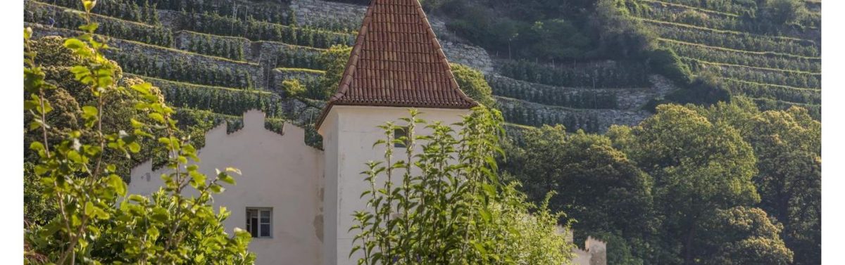
On the eastern edge of the small village of Lasa are the remains of a medieval residence. Of the original building, only a square residential tower with an edge length of 5.2 metres and a wall thickness of 0.65 metres has survived, which on its eastern side has the remains of a coat of arms fresco (royal eagle and golden fleece and four small coats of arms, shield, Tyrol, Austria, Burgundy and the year 1497) and whose defensive plate is crowned by swallowtail battlements. It was later integrated into a complex of buildings. On the opposite, northern side of the street stands an old residential building, which was apparently connected to the residential tower for a long time and formed a unit of ownership with it. Perhaps it was even connected to the tower by a wooden bridge on the upper floor.
Different statements exist about the name of the estate. While the residential tower is almost unanimously named Eyrsburg, the term Moosburg is used either for the opposite residential building, for the complex of tower and residential building, but also as an alternative to Eyrsburg.

Church of St. Peter | Tanas

How to reach the Church of St. Peter

The little church of St. Peter was built in 1396 but was destroyed during the flood of the Tanas river. A new church was built around 1500, the ruins of which can be seen just below St. Peter’s Church. St. Peter’s church, which is still standing today, was built in 1769 in baroque style and consecrated in 1782. The four-station Meditation Trail leads from Tanas to this little church.

Contact:
Church of St. Peter
39023 Tanas
+39 0473 62 65 52
[email protected]
www.kirche-laas.org

Naz-Sciaves

How to reach Naz-Sciaves

Culinary art:
– Hofschank Walderhof | Naz/Sciaves

Eve would really have loved this place: the peaceful and sunny heart shaped high plateau of Naz-Sciaves, stretching along the Valle Isarco, where the 5 pretty villages of Naz, Sciaves, Rasa/Raas, Fiumes/Viums and Aica/Aicha are idyllically situated at heights ranging from 772 m to 890 m, and which offer everything you could want from a holiday destination.

Wander through the countryside and enjoy the mild climate and the magnificent mountain scenery surrounding the spring
blossom, take a summer holiday and relax in the sun, or experience the blaze of colours in autumn during the harvest and the traditional Törggelen. Then add to that the variety of culinary delights and refined cuisine on offer in our comfortable guest houses as well as hotels, pensions and private accommodation, where you will always feel very much at home.

A full programme of elents is arranged to keep our visitors entertained, with summer parties, concerts, slide lectures, special offers such as the children’s programme,
Naz-Sciaves
the activity package, the holiday programme, and the annual “Apple Week and Coronation of the Apple Queen”. The Apple Plateau of Naz-Sciaves – the ideal starting point for excursions in all directions and for day trips to the surrounding ski resorts in winter

Corvara

How to reach Corvara

Attractions:
Passo Gardena | Val Gardena
– Fanes-Senes-Braies Nature Park

Activities:
– Golf Club | Alta Badia

Corvara is located in a favourable and sunny spot in the middle of the Dolomite hiking and skiing area on the Sellaronda, at the foot of the Sassongher mountain, situated at 1,568 m above sea level. There is a long tradition of visitors seeking out this place as a holiday destination.

The first ski school of the valley was founded in Corvara in the 1930s and the first ski lift was constructed in 1938, when the Col Alto toboggan lift was opened. This toboggan lift was replaced in 1946 by a chair lift, the first of its kind in Italy. The Col Alto chair lift went into operation in 1947.

Fanes-Senes-Braies Nature Park | Pusteria Valley

How to reach the Fanes-Senes-Braies Nature Park

The Fanes-Senes-Braies Nature Park covers an area of 25,397 hectares and stretches from the Valle di Braies valley with Lake Braies to Dobbiaco and throughout the Alta Badia.

This reserve is one of the biggest protected areas in South Tyrol and covers the municipalities of Badia, Marebbe, La Val, Valdaora, Dobbiaco and Braies. As the name of the Fanes-Senes-Braies Nature Park – “Naturpark Fanes-Sennes-Prags” in German, “Parco Naturale Fanes-Senes-Braies” in Italian – suggests, on its surface of 25,453 hectares it includes the area of the Braies Dolomites, the Senes Highland and big part of the Fanes Group.

There are also four interpretive nature trails. The Larch Trail connecting the Rüdeferia and Rü farms above San Cassiano in the Val Badia valley forms the border of the nature park. Main topics of the 1 km long trail are the different landscape types such as the larch meadows and forests.

The Lake Dobbiaco Trail, however, takes along the shore of the eponymous lake in the upper Val Pusteria valley and offers 11 interactive stations. It is located exactly on the border with the Three Peaks Nature Park. Furthermore, you can explore the “Maite Fountains” nature trail as well as the “Tru dal’ega” theme Path (Water Trail) near the visitor centre in San Vigilio di Marebbe (St. Vigil).

Opening hours:
Open all year


df

Contact:
Naturparkhaus Fanes-Sennes-Prags
Katharina Lanz Str. 96
39030 St. Vigil in Enneberg
+39 0474 506120

Passo Gardena | Gardena

How to reach the Passo Gardena

The Passo Gardena (Jëuf de Frea in Ladin) proceeds from Selva di Val Gardena to Colfosco, which is part of the municipality of Corvara and with 1,645 m asl. the highest located holiday resort of Alta Badia. A little below the Passo Gardena, findings from the Stone Age were made, a driveway up to the mountain pass was built in 1915, during World War I.

The alpine world on the Passo Gardena is awesome: to the south the massy Sella Group, the Cir Peaks in the Puez Group with the Puez-Odle Nature Park to the north, the Sassolungo Group to the west and to the east the peaks of the Val Badia valley with the legendary Fanes Group. On the ridge, several brooks have their source, one of them is the Rio Frea which flows into the Rio Gardena.

In the middle of the 20th century, the Passo Gardena became relevant for tourism. In 1960 the first road was built, afterwards lift facilities and hiking paths followed. Today the Passo Gardena is one of the four mountain passes of the Sellaronda (a round on skis in winter and a four-passes cycle tour in summer). Moreover hikes into the Dantercepies Valley, to the Alta Via no. 2 or to the Pisciadù Via Ferrata, to mention but a few, start at the mountain pass.

San Leonardo in Passiria

How to reach San Leonardo in Passiria

Attractions:
– MuseoPassiria | S. Leonardo in Passiria
– MuseumHinterPasseier | Passiria
– Alp museum | S. Leonardo in Passiria
– Jaufenburg Castle | S. Leonardo in Passiria

Activities:
– Waterparc | S. Leonardo in Passiria
– Climbing gym | San Leonardo in Passiria

The market town of San Leonardo in Passiria has got some 3,500 inhabitants and is considered the economic and political centre of the village. Part of the municipality are also the villages of Passo, Mora, Prantago, Schlattach, Valtina and Gomion, extending from 693 to 1,262 m asl. The municipal territory is located in the Gruppo di Tessa nature park, at the fork to Passo del Rombo and Passo Giovo.

Meadows, forests and high mountains characterise the landscape round San Leonardo in Passiria. Also from a cultural viewpoint, the village has got some offers, that is to say the MuseumPasseier hosted by the brith place of the Tyrolean freedom fighter Andreas Hofer. Also the Malga Pfistrad and Castel Giovo need to be visited in the charming municipality.

Climbing gym | San Leonardo in Passiria

How to reach the Climbing gym

In San Leonardo in Passiria, theSportArena offers a climbing gym for those who would like to exercise, including 400 sqm, 16 m high rock faces and 101 climbing routes with a difficulty ranging from 3a to 8a and a maximum hight of 19 m. Moreover there are 130 sqm for those who prefer bouldering (154 boulder) with a difficulty ranging from A to F+.

Entry fees:
One day: 6,50 €

Opening hours:
– May 20th – September 4th:
Every day from 10 am to 10 pm
– 1st October to May 19th:
Every day from 10 am to 10 pm

Colfosco

How to reach Colfosco

Attractions:
Fanes-Senes-Braies Nature Park | S. Vigilio
– Golf Club | Alta Badia

What makes Colfosco into a particularly attractive holiday destination are on the one hand the imposing mountains of the Dolomites, which surround it and on the other hand its excellent central location on the Sellaronda.
Situated at 1,645 m above sea level on the edge of the UNESCO World Heritage Site Puez-Odle Nature Park, this calm and peaceful little place offers countless possibilities for a relaxing yet nevertheless active holiday.

Golf Club | Alta Badia

How to reach the Golf Club

In Alta Badia golf-lovers have the possibility of playing on a 9-hole course set in the most breathtaking scenery in the heart of the Dolomites, right under the Sella massif and the Sassongher.

The golf course is at 1700 meters above sea level only a few kilometers from the town centre of Corvara, in untouched nature and with an ideal temperature, far from the summer sultry heat in the valley.

From June to October the conditions are perfect to assure a wounderful round of golf, on a sunny highland with a difference in height of a mere 45 meters.

The course has a club house, putting green, driving range and a professional.

d
Price:

Green Fee 9 holes 40,00 €
Green Fee 18 holes 65,00 €
Driving Range free
Cart 30,00-40,00 €
Trolly 5,00 €
Clubs for hire 15,00 €
Coins (24 Balls) 2,00 €

df

Contact:
Golf Club Alta Badia
Str. Planac 9
39033 Corvara in Badia
+39 0471 836655