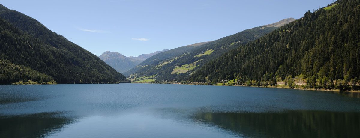
How too reach Stulles Waterfalls
Just below Stulles/Stuls, the third highest waterfall in Europe, cascades down a drop of 112m and then another 230m.
It can be seen from Pianlargo/Breiteben or from the road to Timmeljoch mountain pass.
Erlebnisse in Südtirol
How too reach Stulles Waterfalls
Just below Stulles/Stuls, the third highest waterfall in Europe, cascades down a drop of 112m and then another 230m.
It can be seen from Pianlargo/Breiteben or from the road to Timmeljoch mountain pass.
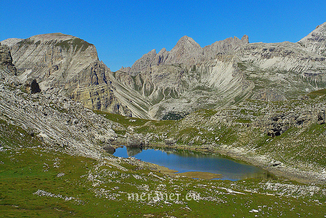
How to reach the Lake Crespëina
Along a hike on the Crespëina Highland towards the Crespëina Ridge and the Cir Peaks in the Val Gardena, the path proceeds past a beautiful mountain lake located at 2,374 m asl. called Lake Crespëina. Around the lake in the Puez-Odle Nature Park the mountains of the Puez Group rise, as the mentioned Cir Peaks. The lake bottom is overgrown with seaweed what gives the green colour to the water – no fish live in it.
The lake is steeped in legend: in former times the lake was called Lech de Lietres what means “Lake of the ladders”. This goes back to the legend, that in the Puez-Odle Nature Park savages were living, who hid in the mountains using corded ladders. A South Tyrolean folklorist of the 20th century, Karl Felix Wolff, tells about it in his sagas.
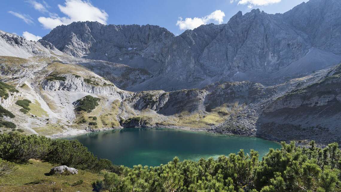
How to reach the Dragon Lake
The Lech dl Dragon is a glacial lake in the holiday village of Selva Gardena in Val Gardena. Located at an altitude of 2,680 m in the Sella Group in South Tyrol, the Dragon Lake is only a temporary water body.
One of the most mystical and undoubtedly most beautiful lakes in Val Gardena is the Lech dl Dragon. The ice reservoir is located on the Val Gardena side of the valley in the middle of the Dolomites at the foot of the Sella Group. There are numerous legends about the lake, especially as the water is not always there. The lake is fed by glacier water and disappeared completely in the 1970s. In the years 2003 to 2007 the turquoise green lake at the Sellamasiv in the Dolomites could be observed, until it disappeared almost completely again in 2009.
A dragon in Val Gardena
Since 2011, the lake seems to be forming again about 300 m further east and it indicates that this lake will become even bigger than all the others have observed so far. The disappearance and emergence of the ice lake has been on people’s minds for generations. So it is hardly surprising that numerous legends and legends entwine around the Lech dl Dragon. It is said that the sounds of the dynamic glacial lake, which can be heard in Selva and in the alpine pastures of the Gardena Pass, come from a dragon flying in the sunset of the Dolomites.
The Lech dl Dragon can be visited together with a beautiful hike. Starting at an altitude of 1923 m at the Gardena Pass car park, you can reach the lake in a four-hour hike. The best months for this hike are August and September.
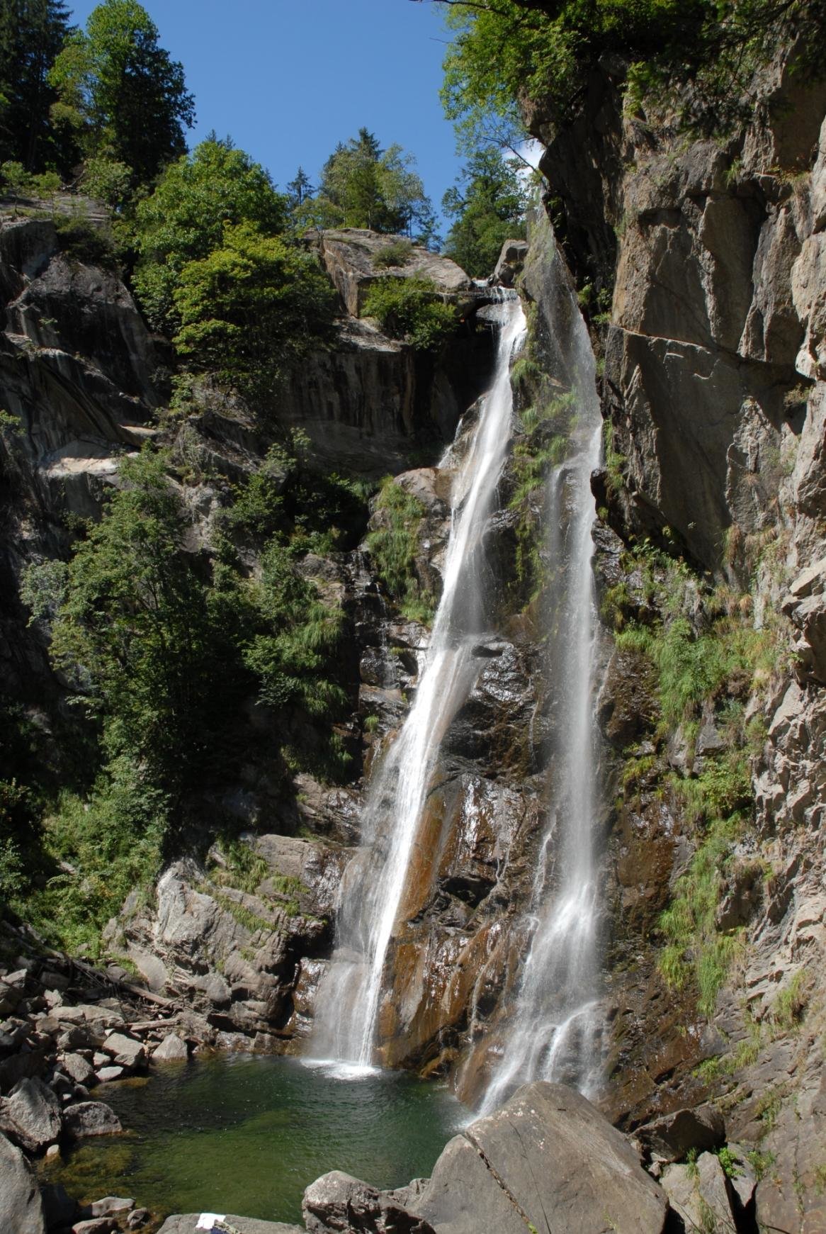
How to reach Passeier Waterfall
The beautyfull Passeier Waterfall is 48 m high and is located at the beginning of the romantic Valley Clava.
You can reach the Waterfall from the Village Rifiano / Riffian, S. Martino / St. Martin or S. Leonardo / St. Leonhard after 45 minutes by walking.
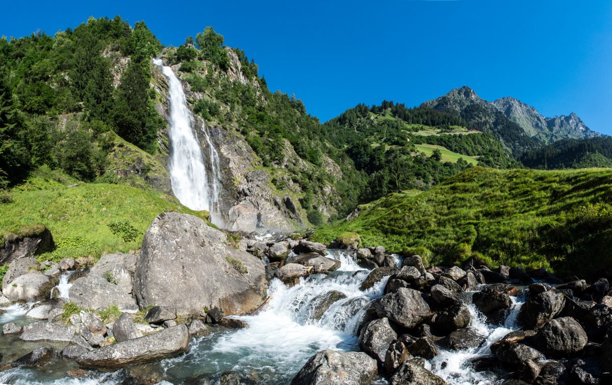
How to reach Parcines waterfall
Considered one of the most spectacular in the Alps, the Parcines waterfall cascades down the rock face from a height of almost 100 m. It is particularly impressive in early spring with the melting of snow, when as many as 6,000 liters of water per second flow into the Zielbach torrent.
The family hike from Parcines to the waterfall takes about an hour and a half on foot and there is also a shuttle bus. A scenic family walk leads from the Texelbahn Cable Car mountain station down to the base of the waterfall.
df
Contact:
Tourist Office Parcines, Rablà and Tel
Via Spauregg. 10
39020 Parcines
+39 0473 967157
Lake of Zoccolo
Lake Zoccolo (1137 m) is an artificial lake with a huge dam and is more than two kilometres long. It is the largest lake in Val d’Ultimo. It is fed by the Valsura stream. Under the water there are twelve farms, for over a thousand years were among the most beautiful in the area.
The Zoccolo lake is located just after the village of Santa Valburga (20 km from Lana). The village of Pracupola (“Kuppelwies”) lies at the mouth of the Valsura stream into the lake.
From Pracupola, the uphill road leads to the Schwemmalm ski and hiking area, to the Quaira lake and to the path to the Covolo lakes.
How to reach Lake of Zoccolo
Lake of Alborelo
The lake of Alborelo (804 m) is the first lake you come across when you enter Val d’Ultimo (13 km from Lana). The lake of Alborelo is located just after the village of San Pancrazio at the exit of the tunnel. It is an artificial lake with a power station.
How to reach the Lake of Alborelo
Lake of Fontana Bianca
The Lake of Fontana Bianca (1872 m) is an artificial lake located at Fontana Bianca. This is where the Valsura stream flows through the Val d’Ultimo and into the Adige river in Lana.
How to reach the lake of Fontana Bianca
Lake Pesce or Lake Pescatori
Lake Pesce (2068 m) or Lake Pescatori is located in Val d’Ultimo along the path that leads to Monte Collecchio (2958 m). It is an area of pasture for cows and horses.
The lake is enclosed by a small artificial dam and is located in a basin. Near the lake there is a large meadow with some benches where you can stop to eat in the bag.
How to reach the Lake Pesce
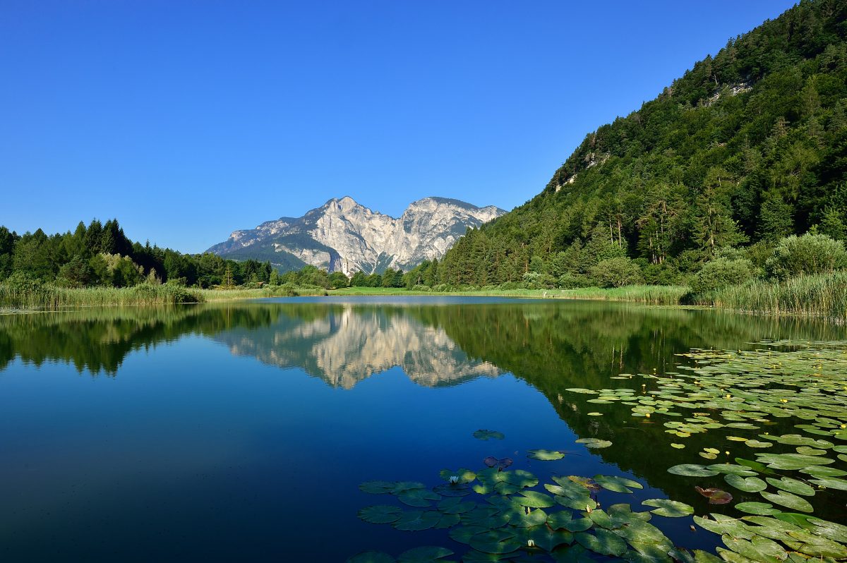
Lago Verde
The Lago Verde (2529 m) in Val d’Ultimo is an artificial lake. All around the lake there are high mountains including the Cima Fontana Bianca (3253 m), Cima Sternai (3443 m), Cima Sternai Meridionale (3385 m) and Gioveretto (3439 m). You can reach Fontana Bianca (1885 m) by car. This is also the end of the Val d’Ultimo road.
How to reach the Lago Verde
Lake of Quaira
Lake Quaira (2250 m) in Val d’Ultimo is an artificial lake surrounded by high mountains. From the village of Pracupola we reach after 7 km by car the restaurant Steinrast (1728 m) which is located at the beginning of a large meadow to the right of the road. Then we park the car along the road.
How to reach the Lake of Quaira
df
Contact:
Tourist office Ultental Valley
St. Walburg 104
39016 Ultimo
+39 0473 795387
How to reach the Biotope Falschauer
The whole Adige Valley was once a giant natural paradise full of ponds, riverside forests and bogs. People would keep away from the marshlands and its bad smell and instead settled on the elevated plains, hills and mountains of the area – not least because of the many floods. That explains the village development in many modern municipalities like Lana, Postal or Gargazzone.
Yet in the middle of the 20th century about 100 hectares of the lands in the river delta of the Valsura lay fallow. In the course of the German and Italian economic miracles the area experienced an unstoppable industrialisation that nearly upset its natural balance. When people started to rethink this ‘progress’ in the 1970’s the remains of the river delta of the Valsura were declared a protected biotope.
Today the delta covers about 32 hectares, it is a refuge for many endangered animals and an irreplaceable habitat for more than 230 species of bird, including 50 breeding birds, amphibians, colubrids, fish and water insects, as well as for numerous rare plants.
Tip
Visitors who walk around in the accessible part of the mostly untouched delta can take a break at the ponds or bogs and listen to the countless number of birds and frogs.
| A visit is possible throughout the year! |
How to reach Lake Favogna
A lovely winding mountain road leads you quickly up from Kurtatsch, through woods, meadows, vineyards, and fruit orchards to the high plateau of Fennberg/Favogna. While Oberfennberg (Upper Favogna, 1163m) with Castel Ulmburg (19th century) and the diminutive Mariahilf chapel (Mary help – 17th century) are private property and part of the community of Kurtatsch, the somewhat lower-lying plateau of Unterfennberg (Lower Favogna, 1047m), a collection of mountain farms and summer houses, belongs to the community of Magrè/Margreid. A beautiful little St. Leonard’s church and two restaurants are the centers of the small, dispersed hamlet.
The jewel of this South Tyrolean plateau is without question little Lake Favogna, perfect for a summer swim. Although the lake is registered as a biotope with unusual flora and fauna, a small wooden platform with a ladder down to the water gives you the chance of swimming in the clear moor water while enjoying the panoramic view of the St. Leonard’s church and the surrounding mountain peaks. Water lilies, reeds, and dragonflies build a summer frame for the lake, which is a popular spot for ice-skating during the cold winter months.
The plateau offers many walking paths as well as the possibility of traveling up by hiking path or via ferrata. The plateau is also an excellent destination for bikers, be it mountain bikers, motorbikes, or racing bikers.
df
Contact:
Tourist board Südtiroler Unterland
Hauptmann Schweiggl Platz 8
39040 Cortaccia
+39 0471 880100
How to reach the big Montiggl Lake
How to reach the smal Montiggl Lake:
The two Montiggl Lakes sparkle like two bright sapphires amidst the dark green forests. A bird’s-eye view provides just a glimpse of the unique leisure area surrounding the two lakes. While from May to September swimming and sunbathing are the order of the day, in autumn and winter nature takes a break, allowing walkers to enjoy peace and quiet. The larger Montiggl Lake offers among other things an open-air swimming pool, South Tyrol’s longest water chute, a high-diving board, a very large sunbathing area and no shortage of places to eat and drink; just a few minutes’ walk to the northeast, meanwhile, the smaller Montiggl Lake offers a more intimate, tranquil atmosphere. Both lakes are ideal for swimming or boating across, and can easily be circuited on foot or by bike.
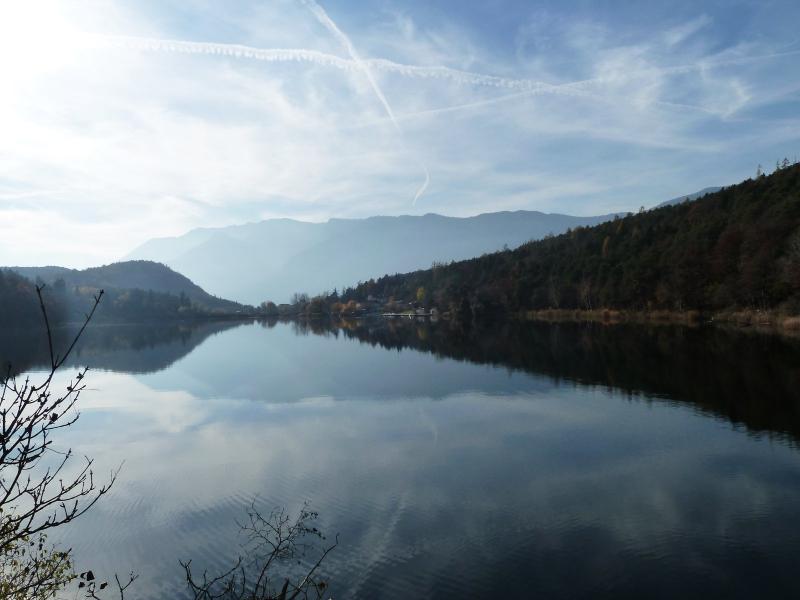
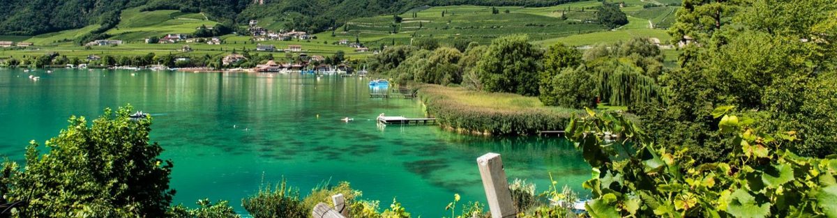
How to reach the Lake Caldaro
Swimming:
– Swimming & beaches | Kaltern
Attraction nearby:
– The ruin Leuchtenburg | Kaltern
The viticultural village has got much to offer both for visitors and inhabitants. One of its main advantages is its lake, well integrated into the great landscape.
Lake Caldaro is the warmest bathing lake in the Alps as well as the largest natural bathing lake in South Tyrol, which does not necessarily mean that it has to be of vast extension, as there are not too many lakes in this area. However, lake Caldaro is well integrated into a beautiful landscape of vineyards and fruit orchards and is dominated by Castel Chiaro, which is located on a hill at the eastern lakeside and represents in a way the symbol of the area.
Lake Caldaro features a lenght of 1.8 km, is 0.9 km wide and covers an area of about 155 hectares.
Located at 216 m asl, its average depth is 3.5 m, while in some places it is even 5.6 m deep. Bathing season normally lasts begins in May and ends in September.
Due to the fact that this lake features the warmest springs in the Alps, every year it is a surprise whether the surface of the lake freezes in winter or not. If so, you can enjoy the lake from a very different point of view.
Lake Caldaro is located about 4 km from the centre of the village. The locality S. Giuseppe al Lago is directly located at the lakeside, in a slightly lonely position, which makes this place a popular holiday destination. S. Giuseppe belongs to the municipality of Caldaro.
Due to its shallow depth of the lake, already in spring the average water temperature of the lake is about 17 to 19 degrees and in high summer the lake even reaches 28 degrees. Due to the position of the lake, the temperature out of the water is about 10 degrees higher than in other mountain areas.
Windsurfers are acquainted with lake Caldaro, as it does not only offer pleasant water temperatures (already in April about 13 degrees) Also the “Ora”, a southern wind breeze blowing around midday offers great conditions for windsurfers. The “Ora” comes from lake Garda throughout the Valle dell’Adige until finally reaching lake Caldaro. A bit of Mediterranean feeling coming from lake Garda makes your holidays even more interesting.
Also another characteristic of the lake attracts lots of visitors. This area is the largest wetland area of South Tyrol and is characterised by reeds and wetland meadows, which are habitat for many waders as well as a resting place for migratory birds. The reeds at the southern lakeside give shelter to many protected animals and is thus a rest zone. Moreover the lake belongs to the “Natura 2000″ network in Europe.
A round course leading round lake Caldaro provides information on vegetation, the relationship between menkind and landscape as well as on flora and fauna on 14 information panels.