Mountain of Colle | Bolzano

How to reach the mountain of Colle

About 10 km from the centre of Bolzano, there is the little mountain village of Colle, representing a real oasis of calm for all those who simply would like to escape the hustle and bustle of the city. A winding mountain road takes to the mountain of Colle, moreover there is a cableway taking from Bolzano to the little mountain village. By the way the Colle funicular is one of the oldest cableways suspended in the air worldwide. Put in operation in 1908, new cabins were installed in 2007. This cableway takes you at 1.250 m asl and is a popular means for transport for those who aim at higher and cooler realms.
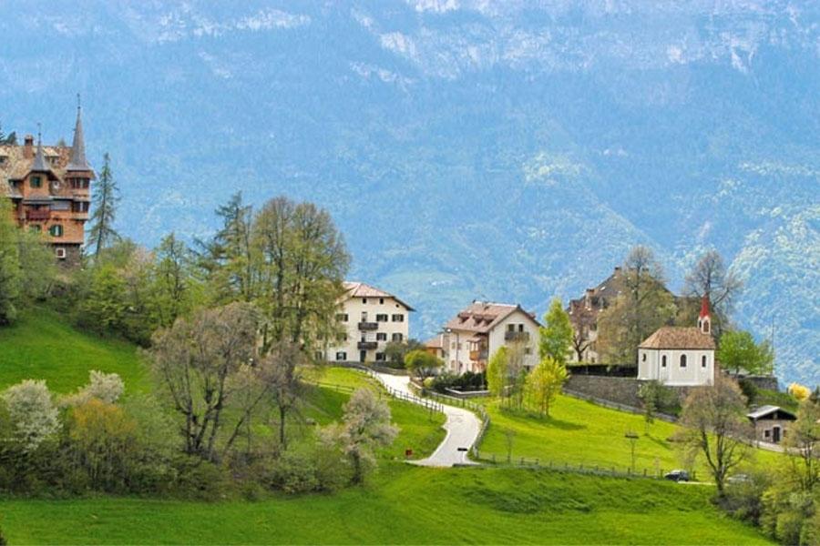
The little settlement, which is made up of Colle di Villa and Colle dei Signori is located in the heart of nature and is surrounded by fabulous forests and meadows. Moreover you can enjoy fantastic clear views, on the city of Bolzano as well as on parts of the Valle dell’Adige and the Oltradige.


Earth pyramids | Terento

How to reach the earth pyramids of Terento 

The formation of the earth pyramids of Terento probably dates back to 1837. The stream of Terner, following a very violent storm dragged away with it 3 houses, 16 mills, 13 pile drivers, the workshop of a blacksmith and a sawmill. 13 people died. It was on that occasion that part of the mountain probably collapsed. In the following decades the erosion involved two different debris rocks: from the material covered with blocks of rock formed the classic earth pyramids, while from the material without the presence of stones formed only ridges and coasts. Starting point: central car park Terento

Calvario mountain | Appiano

How to reach the Calvario mountain

It is definitely an attraction. If you come to the centre of S. Michele, the church at the top of the green hill above the village immediately catches your eyes. If you would like to walk to this place, take the trail of the stations to the cross, taking you to the top. The green hill is called Calvario mountain, boasting several rare natural monuments.

Behind the church, the Adige glacier left some clear marks. One of this marks belongs to the most beautiful in the area of Bolzano. Moreover the moraines, that is to say remnants of the glacier, offer perfect conditions for vineyards, which today yield fruit in this region.

In certain areas, the glacier has formed the stones in such a way, that the so called “devil chairs” developed, characterised by a chair-like structure. A path leads you to these special rock formations. When the ice was melting, the snow-water flowed down, causing this special forming of the porphyry and stone sculptures like the “devil chairs” developed. Enjoy your trip to the Calvario mountain!

Messner Mountain Museum Firmian | Appiano

How to reach the Messner Mountain Museum Firmian

The Enchanted Mountain. The heart of the Messner Mountain Museum, MMM Firmian at Sigmundskron Castle near Bolzano, focuses on the human-mountain conflict.

Within the old walls of Sigmundskron Castle, complemented by a modern structure of steel and glass, beats the creative heart of the entire museum concept. In a tour, pictures, sculptures, symbolic objects and relics tell of the importance of the mountains for people. MMM Firmian is a unique meeting place with great views and insights.


Please check this website for detailed information on opening hours and prices.

df

Contact:
Messner Mountain Museum Firmian
Strada Castelfirmiano 53
39057 Frangarto
+39 0471 631264

Cima Tessa | Val Senales

How to reach Cima Tessa

The Cima di Tessa (3,318 m asl – Texelspitze in German), which gives its name to the mountain range to which it belongs to, is only over-towered by the neighbouring Monterosso (3,337 m asl). The Cima Tessa is located in Val Senales and can be scaled starting from the Val di Fosse, strictly speaking from the Vorderkaser farm (1,676 m asl). A narrow and steep mountain road takes with gradients of about 20% takes to this farm. From the Vorderkaser farm you can also scale the Similaun Glacier.

The Cima Tessa is less popular with mountaineers than with those who love ski touring and it is a well-frequented tour in late spring (April, May). This tour takes you to the Mitterkaser and further on towards the Eishof farm on 2,000 m asl. This is where you traverse the Rio di Fosse and walk on to the foot of the Monterosso, towards the Tessa Glacier. The great views you can enjoy in this tour are just amazing.

The pre-summit can be reached with skis, if you want to scale the summit, crampons are necessary. Caution: the direct and steep descent across the rift towards the Mitterkaser is reserved for experienced ski mountaineers.

Lanserhaus | Eppan

How to reach the Lanserhaus 

Since 2005 there has been a cultural and social centre in Eppan, which emphasises the diversity and economic importance of our large community.
Through extensive restoration work, the Lanserhaus – one of the many historic residences on the Überetsch low mountain range – has been transformed into an attractive cultural and economic centre and made accessible to the public.

Treasures recovered – an archaeological expedition through Eppan
The permanent exhibition in the vaulted hall of the historic Lanserhaus offers an overview of the Eppan settlement history from the Stone Age to the Middle Ages. Original finds are on display, from Neolithic arrowheads to crossbow bolts from the Knights’ period. The exhibits are on loan from the Bolzano City Museum, the Bolzano Museum Society and the State Office for Historical Monuments, which provides interesting objects from the collection of the brothers Max and Walther von Mörl. The exhibition, curated by archaeologist Dr. Hanns Oberrauch, accompanies visitors on an exciting journey through 10,000 years of Eppan history and refers to the numerous archaeological sites in the surrounding area.


For further information on opening hours and prices please check this website.

df

Contact: 
Lanserhaus
J.-G.-Plazer-Straße 22-24
39057 St. Michael/Appiano
+39 0471 667566

Lake di Landro | Dobbiaco

How to reach Lake di Landro

Surrounded by a fantastic mountain and summit scenario, Lake Lago di Landro lies in the inner Höhlenstein valley. This cool wetland is one of the three largest natural lakes in Alta Pusteria in South Tyrol and impresses not only with its spectacular colors but also with its ideal location.

Tourists can reach this turquoise lake from the south of Cortina as well as from the Pusteria Valley, where they can immediately enjoy the unique view of the Monte Cristallo on arrival. The trip already offers a stunning view of the Three Peaks, Monte Piano, or the Paternkofel.

df

Contact
Tourist Info Dobiacco
Via Dolomiti 3
39034 Dobbiaco
+39 0474 972132

Museum Castle Moos-Schulthaus | Eppan

How to reach the Museum Castle Moos-Schulthaus

In Eppan | Piganò, above Castel Gandegg, you find near Castel Englar the residence Moos Schulthaus. A little bit hidden, how it is usual for an insider tip, you can find a nice little museum for Middle Aged living.

Around the middle of the 13th century the dynasty of the Rottenburger built a Romanesque residential tower above the location Pigenò. Around the 14th century it was transformed and extended into a gothic residence for hunting. After the extinction of the Rottenburg in 1410, the complex ended up in the hands of the princes and later on to the Lords of Firmian and around 1500 to the Earl Spaur who expanded it even more. Until the middle of the 19th century it remained in the hands of the aristocrats of Schulthaus. With this intense change of property and the related architectural procedures caused a special fusion of connected elements, interlaced and on different levels situated premises and last but not least style characteristics of different époques. In 1958 Walther Amonn, merchant of Bozen and patron, bought the complex and had it costly restored and opened it for the public in 1985.

Well worth seeing are especially the frescos of the premises, which are a unique example of gothic mural art and give an insight in the life and philosophy of that time.


Please this website for detailed information on opening hours and prices.

dff–

Contact:
Schloss Moos Schulthaus
Schulthauserweg 4
39057 Eppan
+39 0471 660139

San Valentino Lake | S. Valentino alla Muta

How to reach San Valentino Lake

Below the Passo Resia mountain pass, in the municipality of Curon Venosta, another well-known lake is located, Lake San Valentino Alla Muta. The main tributaries are the Rio Serres brook and the Adige river, drained from the neighboring Lake Resia.

Located at 1,450 m a.s.l., Lake San Valentino Alla Muta – “Haidersee” in German, “Lago di San Valentino Alla Muta” in Italian – is not really suited for swimming but a nice excursion destination all year round. A beautiful hiking and nordic walking route proceed around the lake, always with a view of “King Ortles” and the other partly glaciated mountains of the Ortles Alps. Also among bikers, the lake is very popular, as well as sailors and kitesurfers like it. Boating is allowed here, but only with an electromotor. In winter – the lake normally freezes up quite early – Lake San Valentino Alla Muta and neighboring Lake Resia are attractions for iceboat runners and snow kiters.

The hike around the lake (about 2 hours) starts already in Malles and proceeds to the lake biotope with ducks and coots. Then the route runs along the asphalted cycle path further towards Resia and through a forest area to the village of San Valentino Alla Muta. Here the signposts “Uferweg” (Shore Path) mark the way back towards Malles, this time on the left side of the lake.

Aurino Floodplain Forest Biotope | Brunico

How to reach Aurino Floodplain Forest Biotope

A natural treasure can be found in the Val Pusteria valley, on the left bank of the Aurino river, the most important inflow of the Rienza river. Near the villages of San Giorgio and Stegona, the edge of the Aurino Floodplain Forest lies – “Biotop Ahrauen” in German, “Ontaneti dell’Aurino” in Italian -, a protected area which covers a surface of 60 hectares and includes the municipalities of Brunico, Gais, and Campo Tures. Strictly speaking, it is the area of the lower Aurino River between Molino di Tures and Brunico which has been revitalized since 2003.

This pristine alluvial forest has a long history, dating back to the time of the Austro-Hungarian Empire. Nowadays, the area can be discovered on some hiking trails – one of them is the Aurino theme trail (Ahr Erlebnisweg). The path is suitable for prams until a viewing platform which offers a wonderful view of the surroundings. The Aurino Floodplain Forest is a habitat for many species of butterflies, fish, and birds such as the common kingfisher and the grey heron.

The Aurino Floodplain Forest, formed by glaciers in the last Ice Age, still shows how the primeval forest in this region once looked like. It has been placed under protection as a valuable biotope and a bird sanctuary, furthermore it is part of the European-wide Natura 2000 sites. By the way, the Pusterbike Cycle Path of the Valli di Tures and Aurina valleys leads from Brunico to Campo Tures, following partly the course of the Aurino river.